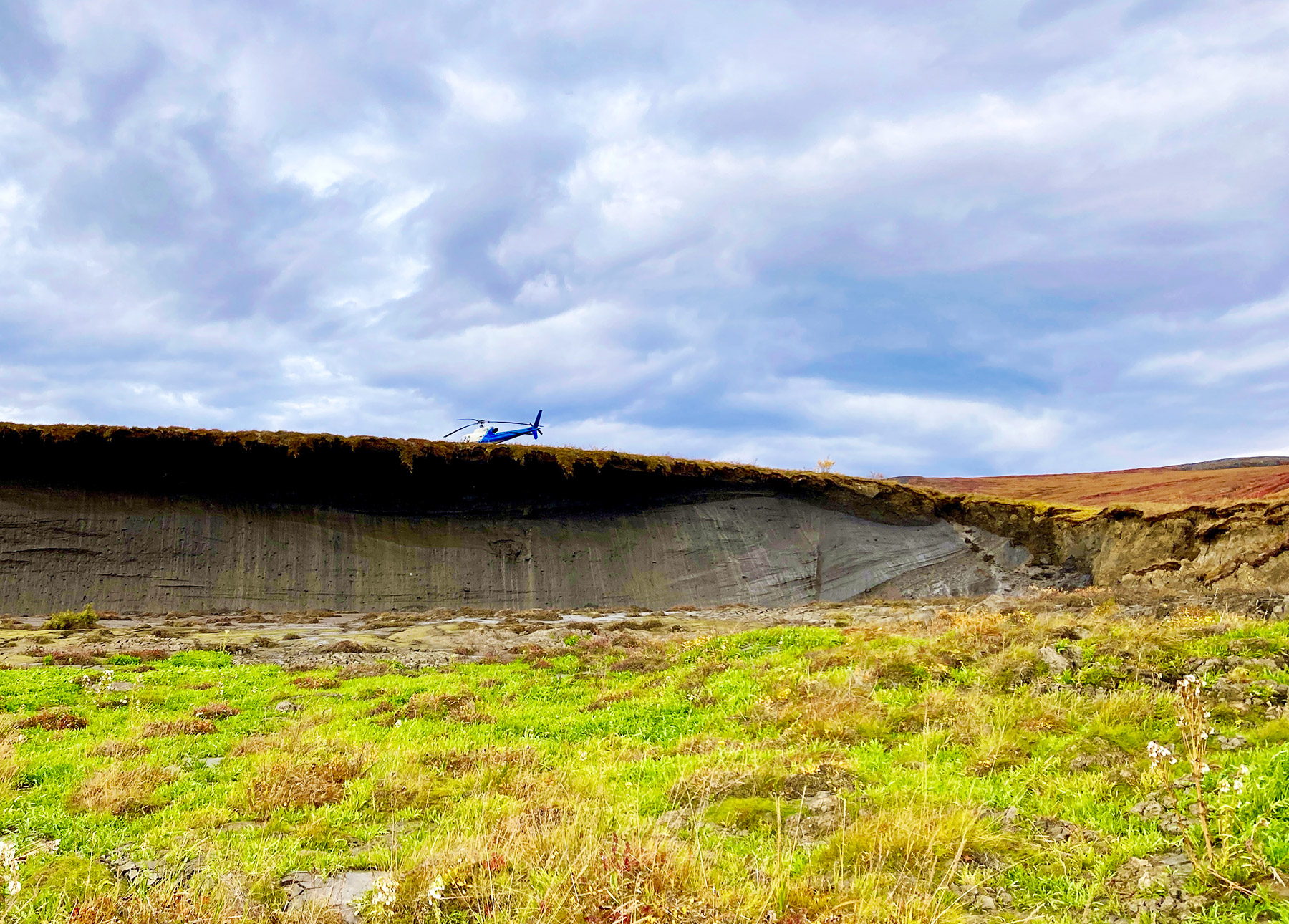
Photo: Headwall of a thaw slump with helicopter, Peel Plateau, Canada. Credits: Carolina Voigt, AWI (2025).
Project: Structure and Work Packages
 is organized in six science work packages (WPs 1-6) that align to address the three knowledge gaps and one work package (WP7) that leads coordination and data management. WPs 1-3 address the better understanding of Rapid Thaw Processes using remote sensing, field observations, process modeling, and deep learning. WP4 focuses field and lab measurements and experiments of Reactivity of Rapidly Thawing Organic Carbon. WP5 assembles field and remote sensing data in deep learning frameworks to derive new Syntheses of Carbon and Ground Ice Distribution. Finally, WP6 leads the model-based Emission Contribution and Global Consequence analysis.
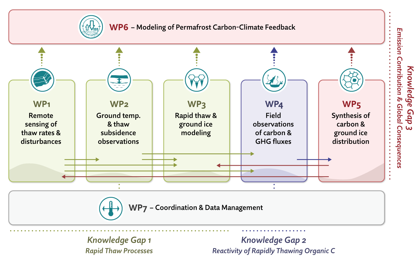
WP1: Remote Sensing of Rapid Thaw Processes
Within WP1, we map rapid thaw features and rates across the pan-Arctic using high-resolution satellite imagery and AI-based detection methods. We combine declassified Corona and Hexagon imagery from around 1970 with recent Planet imagery from around 2025 to produce a multidecadal dataset on thermokarst lake formation, lake shore erosion, and thaw slumping.
Using Convolutional Neural Networks, semi-supervised segmentation, vision transformers, and the DARTS AI-based processing pipeline, we identify, classify, and track disturbance types across broad environmental gradients. WP1 results guide rapid thaw parametrization in WP3 and WP6 and support upscaling of greenhouse gas fluxes in WP4.
WP2: Ground Temperature and Thaw Subsidence Field Observations
Within WP2, we establish a distributed observational network at selected long-term monitoring sites in Alaska, Canada, and Finland to investigate ongoing and potential near-future rapid thaw subsidence. We monitor ice-rich permafrost settings including Yedoma formations, peat plateaus, palsas, thermokarst ponds and lakes, gullies, and thaw slumps.
Using Campbell and Hobo Onset sensors, we measure air and ground temperature, liquid water content, and snow dynamics, complemented by near-surface ice and organic matter measurements. Repeated high-resolution drone surveys quantify interannual thaw subsidence and support model verification. We further develop site-specific numerical models to simulate permafrost dynamics, talik formation, and thaw subsidence under present-day conditions and future SSP2 and SSP5 scenarios.
WP3: Rapid Thaw Processes Modeling and Ground Ice Projection
Within WP3, we develop model representations of rapid thaw processes and ground ice dynamics to address a major blind spot in current Earth System Models. We simulate the evolution of ice-rich permafrost landscapes from the Last Glacial period to today, focusing on how gradual and rapid thaw interact and how past landscape evolution shaped present-day ground ice distribution, topography, and hydrological networks.
We enhance CryoGrid(Lite) using laterally coupled tiles to represent rapid thaw processes while maintaining process complexity at large scales. We further incorporate lateral processes such as gullying, slumping, and lakeshore erosion as stochastic elements within the CryoGrid tiling framework. Using PMIP4-CMIP6 experiments together with SSP2 and SSP5 climate projections, we conduct pan-Arctic simulations of past and future thaw dynamics and associated uncertainties.
WP4: Fate of Abruptly Thawed Permafrost Carbon in Terrestrial and Aquatic Systems
Within WP4, we investigate how abruptly thawed permafrost organic matter decomposes and contributes to CO₂ and CH₄emissions in terrestrial and aquatic systems. We combine field observations, laboratory experiments, and pan-Arctic datasets to study thermokarst lakes, thaw slumps, thawing peatlands, streams, rivers, and other thaw-affected landscapes.
We collect new field data along thaw gradients in Yedoma and non-Yedoma landscapes in Alaska, Canada, and Finland, while also leveraging datasets such as BAWLD-CH4 and ABCflux. Plot-scale in-situ CH₄ and CO₂ fluxes, isotope measurements (14C, 13C), laboratory incubations, and climate chamber mesocosm experiments help us quantify greenhouse gas production, decomposition processes, nutrient release, and carbon turnover under realistic environmental conditions.
WP5: Synthesis of Pan-Arctic Carbon Stocks and Ground Ice from Improved Landform Mapping
Within WP5, we produce new pan-Arctic maps of periglacial landforms, soil carbon, nitrogen, and ground ice to support improved modeling of thermokarst and rapid thaw dynamics. We use several thousand field observations and more than 20 existing high-resolution landform maps to train RF and ANN algorithms that predict landform types from geospatial datasets.
The resulting products provide 10-30 m resolution maps of landforms, soil properties, and ground ice distribution across the Arctic. We further combine landform, carbon, and ice datasets with information on topography, vegetation phenology, and surface hydrology to generate generalized permafrost landscape maps for use in WP1, WP3, WP4, and WP6.
WP6: Projection of Permafrost Carbon Emissions and the Permafrost-Carbon-Climate Feedback Strength
Within WP6, we investigate how rapid permafrost thaw alters future carbon emissions, climate feedbacks, and the remaining global carbon budget. We advance ICON-ESM together with the Jena Soil Model by integrating simplified representations of rapid thaw effects on ecosystem states based on dedicated models developed in WP3.
We additionally incorporate methanogenesis and methanotrophy processes to mechanistically predict the CH₄:CO₂surface emission ratio. Flux measurements and mesocosm experiments from WP4, together with datasets from WP1 and WP5, are used to calibrate and initialize future carbon cycle and climate simulations.
WP7: Project Coordination and Data Management
Within WP7, we coordinate PeTCaT’s scientific, administrative, outreach, and data-management activities. We support collaboration across the project through regular meetings, workshops, reporting, communication with VICC, and maintenance of the PeTCaT website.
We also coordinate open-access data management and long-term archiving of datasets, models, and code. A key responsibility of WP7 is to further develop the Data Platform for the Global Terrestrial Network for Permafrost (GTN-P). This involves providing Permafrost Temperature and Active Layer Thickness datasets to support future modelling efforts relating to the permafrost and carbon cycles.